Some Strange Weather in the Works for This Weekend of April 7 and 8 (4:17pm, Thursday, April 5, 2018)
Find this article at: go.ncsu.edu/readext?519636
— Written By Barclay Poling en Español / em Português
Español
El inglés es el idioma de control de esta página. En la medida en que haya algún conflicto entre la traducción al inglés y la traducción, el inglés prevalece.
Al hacer clic en el enlace de traducción se activa un servicio de traducción gratuito para convertir la página al español. Al igual que con cualquier traducción por Internet, la conversión no es sensible al contexto y puede que no traduzca el texto en su significado original. NC State Extension no garantiza la exactitud del texto traducido. Por favor, tenga en cuenta que algunas aplicaciones y/o servicios pueden no funcionar como se espera cuando se traducen.
Português
Inglês é o idioma de controle desta página. Na medida que haja algum conflito entre o texto original em Inglês e a tradução, o Inglês prevalece.
Ao clicar no link de tradução, um serviço gratuito de tradução será ativado para converter a página para o Português. Como em qualquer tradução pela internet, a conversão não é sensivel ao contexto e pode não ocorrer a tradução para o significado orginal. O serviço de Extensão da Carolina do Norte (NC State Extension) não garante a exatidão do texto traduzido. Por favor, observe que algumas funções ou serviços podem não funcionar como esperado após a tradução.
English
English is the controlling language of this page. To the extent there is any conflict between the English text and the translation, English controls.
Clicking on the translation link activates a free translation service to convert the page to Spanish. As with any Internet translation, the conversion is not context-sensitive and may not translate the text to its original meaning. NC State Extension does not guarantee the accuracy of the translated text. Please note that some applications and/or services may not function as expected when translated.
Collapse ▲
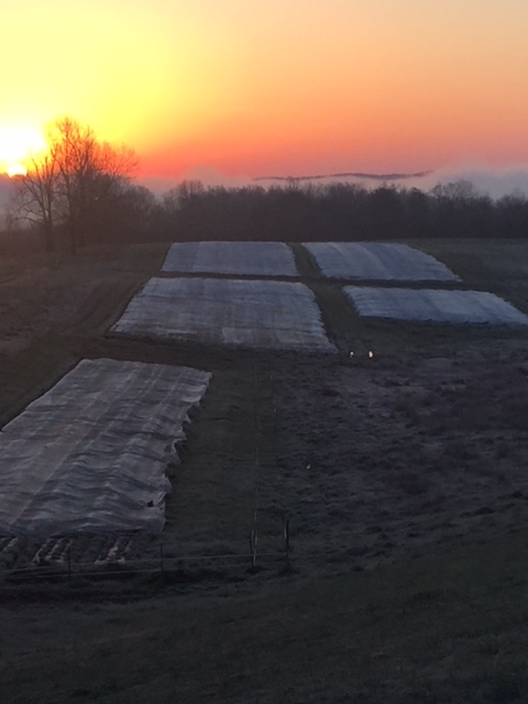
Fig. 1. It was 27 F this morning at Danny Van Meter’s farm in Kentucky!
Good afternoon,
A grower from Roper, NC (the Inner Banks of NC), just now sent Mark and I an interesting note:
I just looked at my AWIS Edenton and Ahoskie, NC and had flashbacks of April 8, 2007[Easter Sunday]. The difference is it looks like a windy cold. I’m thinking that we will put on our covers tomorrow evening (Friday), let it rain on them Saturday, and if they don’t dry before it gets critical Saturday night and Sunday morning start overhead irrigation. Scot Luton, Roper, NC
I just sent Scot a note at 3 p.m. this Thursday stating that:
1) the really great news is that this is definitely NOT shaping up like Easter Freeze of 2007 (with howling winds and temps in teens) – though it is very curious how this particular event it is falling on Saturday, April 7 and Sunday, April 8, as it did in 2007!
2) After studying your situation in Edenton and Ahoskie, I feel that your strategy is a good one:
a) put covers on Friday evening
b) Let it rain Saturday (they are expecting about 1/2 inch between 3P-12M – so, very unlikely the covers will be dry)
c) Monitor blossom temps under the covers on Sunday morning (if you have dig therm with thermocouple wire inserted in bloom) and if the blossoms start dipping below 32 F, start up sprinkling. The minimum for Roper NC may be around 31 F at 5 a.m. And, at that hour winds are “suppose to be” up around 4-5 mph and the dewpoint is hovering around 28-30. If those winds “lay down” there could be a damaging frost event!
d) I also said, “If you do not have dig therm, and the covers start to show signs of freezing up, run the irrigation!”
One thing that I do wish to quickly point out re: Scot’s situation is that in his favor is the FACT THAT HE HAS SPRINKLER IRRIGATION (after this spring season, and all the difficulties we’ve had with wet covers and frost events, I would definitely be in the market during the off-season for a sprinkler irrigation system as a back-up). The great thing about having sprinklers is that you can “add heat” back into the system by sprinkling (continuously) over the top of the covers. By doing this, you can keep the blossoms above 32 F. Without sprinklers, the wet row covers can “freeze up,” and that can be a real problem for any blossoms in direct contact with the iced-up covers — they will likely be killed.
VA grower facing rain, then snow this weekend:
I also got a text from a grower in the area of Lynchburg, and his situation is more concerning because of a forecast minimum of 23 F, and there will be a good 8-9 hour stretch of sub-freezing temperatures in this area from midnight until about 8 a.m. Sunday morning. This grower does not have sprinklers — only row covers. The grower wrote:
“We have rain/snow coming Saturday. And, low of 24 Sunday (another service says 23). Should I pull double covers FRIDAY on my early strawberries that are in bloom? Or, will it not make a difference with all that cold water?”
I called the grower, and we discussed his forecast, and how it has been changing. The current forecast is for about 0.15″ rain between 7A Sat and Noon Sat, and then snowing from 3P to 5P and then “possibly” from 6P-7P its back to rain. Just unbelievable!! What we really don’t know for sure are the snowfall amounts – earlier today they were expecting an inch or more, but now it looks like the snowfall amount may be only 0.06″. I was truly hoping for at least one inch of snow – the snow can provide some actual insulation. So, now it does NOT appear there will be much of an insulating effect from the snow. And, the concern is that the covers will freeze up, and in the absence of sprinkling, this is definitely a worrisome situation. However, I also think things could be a lot worse, especially if the temperatures were going to be down in the 23-25 range for more than a few hours. You can see below (Table 1) that there will be a period between 4 a.m. and 6 a.m. when the air temp will be below 27, and this is when the open blossoms would likely be killed if the grower “did nothing.”
But, what is “in play here” is the possibility of applying double covers on Friday afternoon (tomorrow) to protect open blooms, and I like this strategy because the rainfall amounts are not very heavy on Sat. (my worst fear is drenching rains that cause the wet covers to look molded to the plants), and there is even hope that the covers might be semi-dry going into the night.
So, with the covers not being fully frozen into the plants (hopefully some good air spaces beneath the cover), and the chance of a light insulating snow on top, I do see real benefit to applying the covers tomorrow afternoon. Reason: without this row cover protection, air temperatures may fall into the mid–20s, and that can do serious damage to unprotected open blooms.
BTW: I have done some field research studies at the Clinton Hort Crops Res Station many years ago where we found open blooms and popcorns tolerated 26.7 F, but no lower.
Let’s be clear, I would much rather have the option to sprinkle on top of the covers in a dicey situation like this with covers going into the night moist/wet. So, we are going to have to keep our fingers crossed that this strategy works out!
Soon after I gave this recommendation to the grower in VA, I also called the person in the Southeast with as much as experience with row covers as anyone I know, Eric Hunter, Easley, SC, and he concurred with this approach.
Table 1. Minimum hourly temps in Rustburg, VA, April 8 (Sunday)